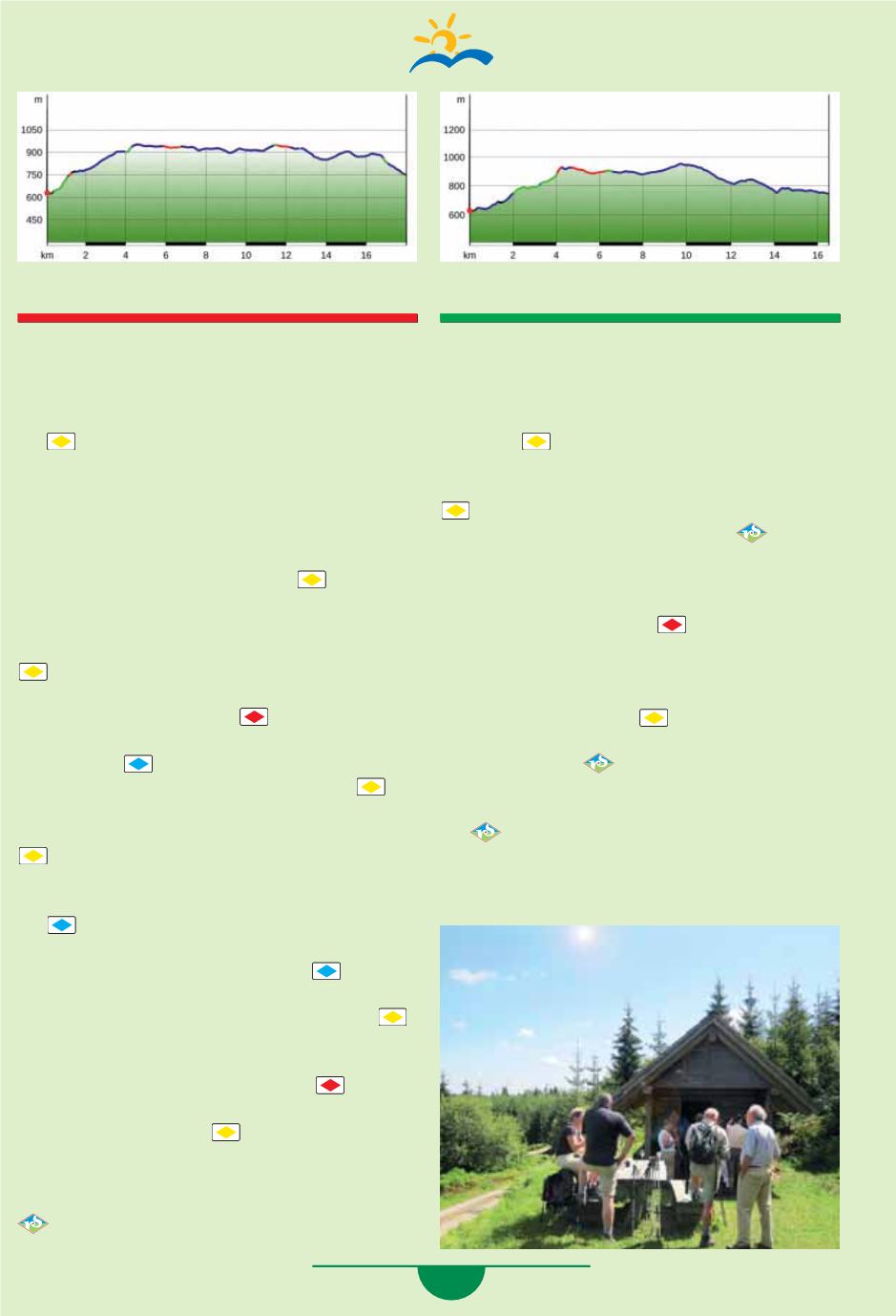
47
Hike 6 “Red Path”
Starting point Dollenberg:
18 km, ascent 652 m / descent 539 m
From the hotel, follow the path to the right across the
car park to the
“Dollenberg”
location. Now follow
the
(yellow rhombus) to the left uphill, cross the
street, and go about 20 m to the left uphill to the
“Renchtalblick”
car park. Follow the highway
downhill to the right, and turn into the path in the
forest at the next hairpin curve. At the “
Müsel-
grund”
location, turn right into the Brünnelweg to
the 1st fork in the path, then leave it
and
continue uphill on the
“Änderlishüttenweg”.
At the intersection, turn left go slightly downhill and
right uphill on the next path. You‘ll be back on the
(yellow rhombus), turn right, pass the windmill,
cross the street to reach the
“Neuer Höhenweg”
location. Follow the Westweg
(Schanzenweg) to
the right towards
“Wolfursprung”. “Wolfursprung”
location right
(blue rhombus).
“Am Grenz-
weg”,
left at the
“Moos”
location and follow
and the
“Heimatpfad”,
cross the highway, go to the
right to the
“Kniebis Stadion”
location. Follow the
to the left to the
“Rankweg”
location, there go
to the left towards
“Ellbachseeblick”
(pass the char-
coal piles on the right). At
“Ellbachseeblick”
on the
left
follow towards
“Alexanderschanze”,
turn
right at Guterbrunnenweg, turn left at the next fork
in the path. At the Seehaldeweg, leave
(blue
rhombus) to the right (notice - no path markings for
1.2 km). At the next fork in the path, follow the
left, cross the B 500 highway at the
“Zimmerholz”
car park, and go straight ahead slightly downhill. At
the
“Am Badberg”
location, follow the
Westweg
towards
“Zuflucht”
until you reach the
“Härtle”
location. Follow the links
downhill to
“Schön-
grund”,
go to the left and choose the Pionierweg to
the right uphill (notice: no path markings for 2 km)
to the
“Kohlgrube”
location. There we will reach the
Renchtalsteig that you will follow all the way to
the Renchtalhütte.
Hike 7 “Green Path”
Starting point Dollenberg:
16.5 km, ascent 660 m / descent 580 m
From the hotel, go to the left across the car park to
the
“Dollenberg”
location towards Teufelskanzel,
follow the
(yellow rhombus) past the distillery.
Go uphill to the left before the street, cross the stre-
et, and walk up the Kirchsteinbruchweg. Follow the
further to the
“Teufelskanzelweg”
location.
There we will reach the Renchtalsteig
and go
to the right uphill via the Teufelskanzel to the
“Teufelskanzel”
location, go left towards Blitz-
hütte then left uphill to the
“Schnepfenmoos”
location. Take the Westweg
to the left towards
“Alexanderschanze”,
pass the “Hildahütte”, after
200 m sharp right and turn right at
“Graseck”,
too. At the
“Neuer Höhenweg”
location, we cross
the street and follow the
(yellow rhombus) to
the
“Oberer Leitweg”
location. There we reach
the Renchtalsteig
again and walk past the
Renchquelle to the
“Schöngrund”
location.
Follow the path to the left downhill, following
the
until the
“Mittlerer Brandweg”
location,
go left 200 m downhill into the valley, then to the
right Mittlerer Brandweg - Renchtalhütte.


